


Clay Township Map |
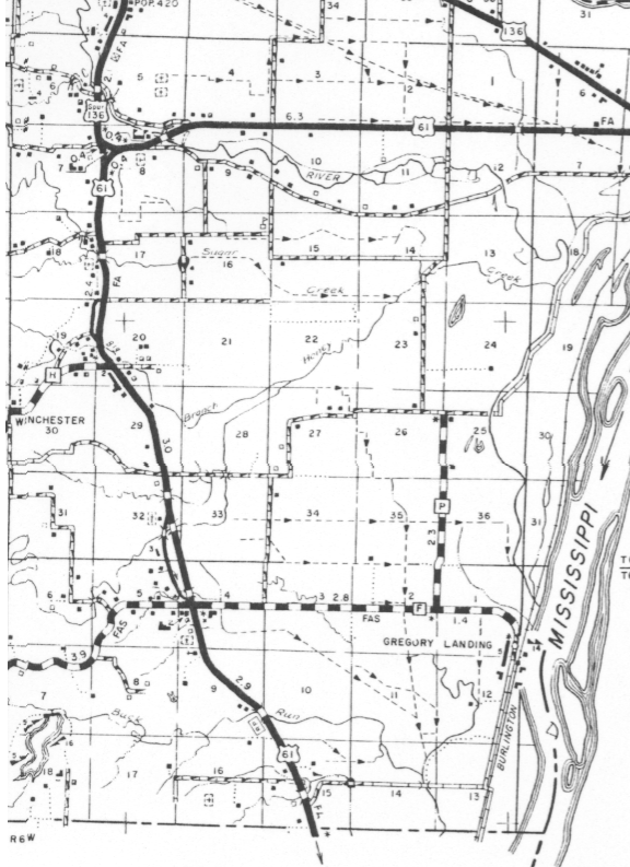 |
| Clay Township is made up of Section 1 through 36 Township 64 North Range 6 West, and Section 1 through 18 Township 63 North Range 6 West for a total of 54 square miles. |
Cemetery
| Cemetery Name | Latitude (NAD83) (D.d) |
Longitude (NAD83) (D.d) |
Section | Note |
|---|---|---|---|---|
| Frazee Cemetery | 40.361111N | -091.579167W | S. 8, T64N R6W | 1* |
| Bluff Springs Cemetery | S. 4, T63N R6W |
2 |
||
| Boulware Family Cemetery | S. 9, T63N R6W | 6 | ||
| Henshaw Cemetery | S. 6, T64N R6W | 3 | ||
| Mitchel Cemetery | S. 18, T64N R6W | 4 | ||
| Chapman Family Cemetery | S. 18, T64N R6W | 5 | ||
| Morris Cemetery | 40.373056N | -091.572778W | S. 5, T64N R6W | 8* |
| Weaver Cemetery | 40.369722N | -091.577778W | S. 5, T64N R6W | 7* |
| Unknown | S. 16, T63N R6W | 9 | ||
| Unknown | S. 32, T64N R6W |
10 |
| Note # | Information on Cemetery |
|---|---|
|
1 |
The Frazee Cemetery is located in Section 8 North in Clay Township west from Alexandra, on Highway 61, and lies on the left side of the road just before coming to Highway junction 61 and "136-I27. "The cemetery is in the book "Cemetery Inscription of Clark County Missouri" page 152 – 168. Latitude and Longitude from GNIS Web page. |
|
2 |
The Bluff Springs Cemetery is located in Section 4 South in Clay Township, to the west and up the hill from the Bluff Springs Methodist Church on US Highway 61, ¼ mile South of intersection “Z/61” on the West side of Highway 61. The cemetery is in the book "Cemetery Inscription of Clark County Missouri" page 169 – 176. |
|
3 |
The Henshaw Cemetery is located in Section 6 North in Clay Township. The cemetery is in the book “Cemetery Inscription of Clark County Missouri” page 176. The direction given in the book is “Located behind the Guerney Riffle house about 2 city blocks and on the farm of Nate Henshaw”. The “Clark County Missouri 2000 Plat Book” indicate a cemetery on the land of Gary L Meinhardt on the south side of county road 307, page 22. The “Clark County Missouri 2005 Plat Book Millennium Edition” does not indicate a cemetery, but Gary Meinhardt is the owner of the land, and County Road 307 is still indicated, page 23. |
|
4 |
The Mitchel Cemetery is located in Section 18 North in Clay Township. Located about one mile south of the Wayland "Y" on Highway 61 on the West side of the road. The cemetery is on the Glenn Wapples farm about three blocks from the house, up a hill and very hard to get to. The cemetery is in the book "Cemetery Inscription of Clark County Missouri" page 177. The “Clark County Missouri 2005 Plat Book Millennium Edition” indicated the land owner is Sharon Waples Etal. (Etal. = “and other” or “and elsewhere”) page 23. The 1878 map indicate a cemetery page 23A. |
|
5 |
The Chapman Family Cemetery is located in section 18 North in Clay Township. On highway 61 after passing Wayland "Y", take first gravel road to the right (County Road 312) and stop at first house. Cemetery is located behind the (Robert Egley ?) home. The cemetery is in the book "Cemetery Inscription of Clark County Missouri" page 178. |
|
6 |
The Boulware Family Cemetery is located in section 9 South in Clay Township. Located on top of a hill, one-half mile South of Bluff Spring Church on Highway 61 on the Robert C. Craw Farm. The “Clark County Missouri 2005 Plat Book Millennium Edition” indicated the land owner is Lucretia Craw Etal. Page 27. The cemetery is in the book "Cemetery Inscription of Clark County Missouri" page 178. |
|
7 |
The Weaver Cemetery is located in section 5 North in Clay Township. This Cemetery is located on the Leon Beard Farm. The “Clark County Missouri 2005 Plat Book Millennium Edition” indicated the land owner is Jeffrey Shaffer Farm. Page 23. The cemetery is in the book "Cemetery Inscription of Clark County Missouri" page 178. Latitude and Longitude from GNIS Web page. |
|
8 |
The Morris Cemetery is located in Section 5 North in Clay Township. Going West on Highway 136 and 61 from Alexandria, just before crossing the big Fox River bridge, there is a gravel road to the right, first house on the right is the Herbert Egley farm. Cemetery is about a mile back on this farm. The cemetery is in the book "Cemetery Inscription of Clark County Missouri" page 178. The “Clark County Missouri 2005 Plat Book Millennium Edition” indicated the land owner is Cleta Egley Trust Etal. Page 23. Latitude and Longitude from GNIS Web page. |
|
9 |
"The unknown cemetery in Section 16, 63 N, Clay township, Clark Co., MO, contains the remains of a number of the BROWN family. Many years ago I discovered this small graveyard and found it bulldozed aside by the local farmer in order to gain more crop land. Yet still, I managed to scavenge enough broken bits of tombstone to piece together one that read "Ann, consort of Henry Brown". She was a Northcraft. The Browns were of my family, having come to Clark County from Shenandoah Co., VA, with the Northcrafts and Smoots in late 1820's - 1830's. Henry and Ann's daughter, Retty ("Rittie") married William Henry Bash -- their daughter, Serina Ann, married Philip S. Barkley in 1884." I thank Cleve Barkley for the above information. The Cemetery is not listed in the book "Cemetery Inscription of Clark County Missouri". The “Clark County Missouri 2005 Plat Book Millennium Edition” indicated the land owner is J. & L Farms. Page 27, and on page 27A the 1878 plat map indicate the present of a cemetery in Section 16. |
10 |
The unknown cemetery in Section 32 North in Clay Township is not listed in the book "Cemetery Inscription of Clark County Missouri". |
|
D.d |
Decimal Degrees is one of sever ways to state Latitude and Longitude coordinates. |
NAD83 |
NAD 83 is one of several hundred map datum. When you use two different type of map datum your location can be several miles off. NAD 83: North American Datum 1983; Used by new Canadian and U. S. maps, digital data or paper. |
Schools
| School Name | Latitude (NAD83) D.d |
Longitude (NAD83) D.d |
Section |
|---|---|---|---|
| Mount Albia School | 40.370000N | -091.588055W | S. 5 T64N R6W |
| Plainview School | 40.365833N | -091.536111W | S. 3 T64N R6W |
| Keystone School(1) | 40.348056N | -091.551666W | S. 16 T64N R6W |
| Long Star School (2) | 40.322222N | -091.517500W | S. 23?(26) T64N R6W |
| Pleasant Hill School | 40.325278N | -091.586111W | S. 20?(29) T64N R6W |
| Gravel Hill School | 40.286389N | -091.569444W | S. 4?(5) T63N R6W |
| Gregory School House | (3) | ||
| Bush School | (4) | ||
| Running Fox School (5) | 40.371666N | -091.587777W | S. 8 T64N R6W |
Note: Section with ? mark could be in a different section
| Note No. | Note: |
|---|---|
1 |
Picture of Students of |
2 |
Listed as Historical on USCG Web page |
3 |
Listed on USCG Web page as unknown, but could be at Gregory Landing. |
4 |
Listed on USGS Web page as on map Kahoka SE. |
5 |
Consolidate School |
This page last updated: Wednesday, September 17, 2014 10:19